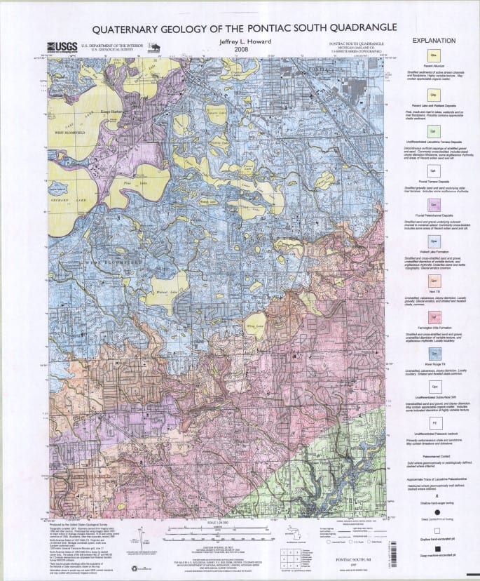
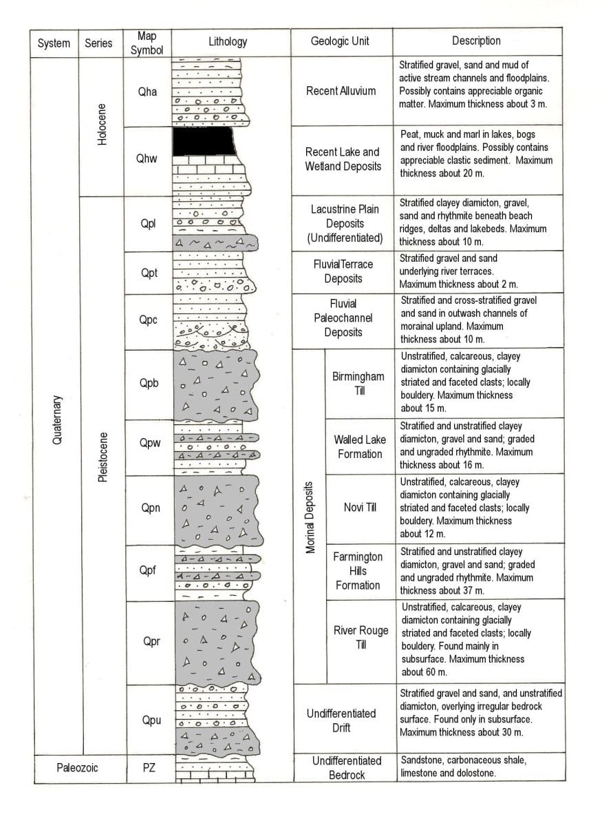
Quaternary geologic maps only show geological deposits of Pleistocene and Holocene age. They are maps of surficial deposits, i.e. sediments which are found directly beneath the ground surface, and which are comprised of earth materials of both natural and anthropogenic origin.

Explanation of Quaternary Geologic Maps
| Map Symbol | Lithofacies | Interpretation |
| Dg | gravelly diamicton | debris flow |
| Ds | sandy diamicton | debris flow |
| Dsi | silty diamicton | debris flow |
| Dc | clayey diamicton | debris flow or till |
| G | gravel | fluvial or lacustrine (beach ridge) |
| Gs | sandy gravel | fluvial or lacustrine (beach ridge) |
| Sg | gravelly sand | fluvial or lacustrine (beach ridge) |
| S | sand | fluvial, lacustrine, eolian |
| Si | silt | fluvial or eolian |
| C | clay | fluvial or lacustrine |
| P | peat | lacustrine swamp or bog |
| M | marl | lacustrine swamp or bog |

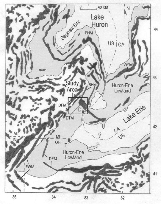

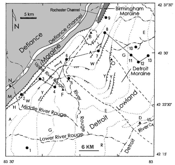
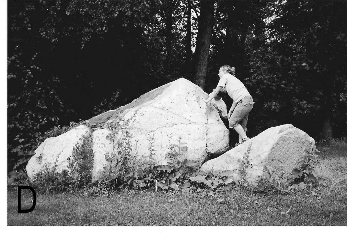
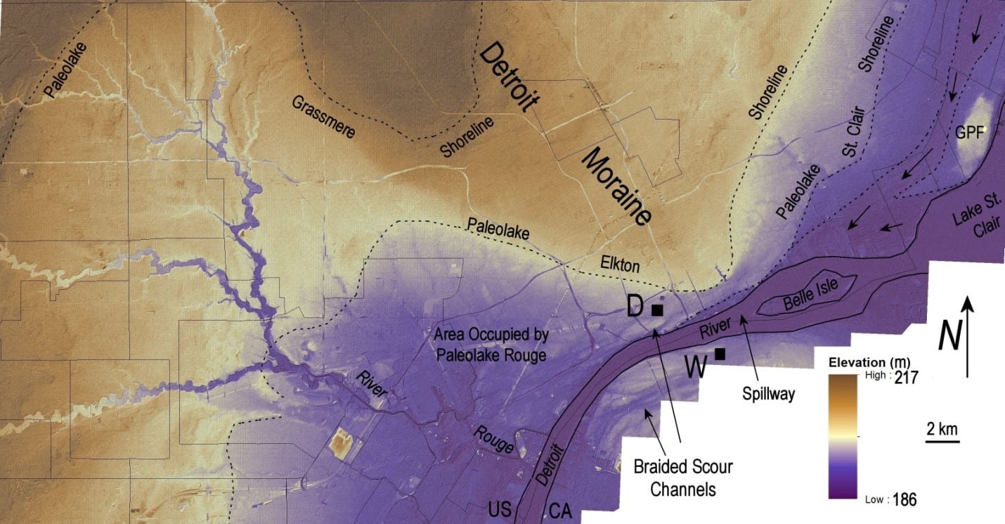
The area mapped consists of 15 USGS 7.5 minute topographic quadrangles which encompass much of the metropolitan Detroit, Michigan area. The area is located between 42°15′ and 42°37’30” latitude; and between 83° and 83°37’30” longitude. Mapping shows that the area is a relict Late Pleistocene glacial landscape on which is superimposed a Holocene system of streams, lakes and wetlands. The glacial landscape consists of a morainal upland, characterized by knob-and-kettle topography and a series of outwash channels, bounded on the southeast a widespread lacustrine lowland. The morainal upland has been delineated previously as an “interlobate” terrain of the Huron and Saginaw lobes, and parts of the Ft. Wayne, Defiance and Birmingham Moraines. The lacustrine lowland (Detroit lowland) consists of the Detroit Moraine, and a series of lacustrine terraces that descend in elevation progressively eastward related to glacial Lakes Maumee, Arkona, Whittlesey, Warren, Wayne, Grassmere, and Elkton. Along the Detroit River, this late Pleistocene lacustrine paleotopography was modified by glacial outburst mega-flooding during the mid-Holocene. Geomorphic features produced by mega-flooding include braided scour bars and channels, streamlined erosional residuals, and boulder-lag deposits.
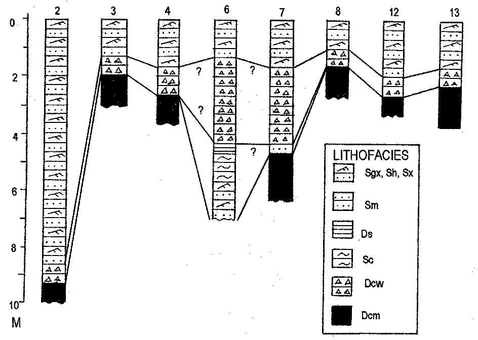
Metropolitan Detroit is underlain by Paleozoic sedimentary rocks overlain by a sequence of Quaternary sediments 10-120 m thick. Stratigraphically, the Late Pleistocene section underlying the morainal upland is thought to be comprised of three till units (River Rouge, Novi and Birmingham tills) composed of massive clayey diamicton; two lithologically variable units of ice contact affinity (Farmington Hills and Walled Lake formations) composed of diamicton, alluvial sand and gravel, and rhythmite; and deposits of alluvial sand and gravel underlying outwash channels and river terraces. The River Rouge till is thought to extend eastward from beneath the Defiance moraine where it is present in the subsurface throughout the Detroit lowland. The Late Pleistocene Lacustrine Terrace Deposits unit lying directly beneath the Detroit lowland is comprised of a basal lithosome of bedded clayey diamicton, overlain by sand, gravel and rhythmite associated with relict lakebed plain, beach ridge and deltaic landforms. The Holocene section includes Recent Lake and Wetland deposits comprised in part of marl, peat and muck, and Recent Alluvium associated with the River Rouge, and Detroit, Huron and Clinton Rivers.
The gross structure of the morainal upland is a homocline dipping gently southeast. Folding and normal faulting, found in the subsurface, are related to the development of knob-and-kettle topography along the crest of the morainal upland. The map area is south of the region being affected significantly by post-glacial crustal rebound and is not thought to be seismically active. Traditionally, the relict glacial landscape was thought to have been formed during the early Port Bruce phase of Late Wisconsinan time, about 14,800 yr BP, by the Saginaw and Huron lobes of the Laurentide Ice Sheet. However, we obtained two new OSL dates of ~18,755 and 18,582 yr BP on the Farmington Hills and Walled Lake formation, respectively, indicating that some ice contact sediment of Nissourian age is also present, at least locally. Provenance analysis of till clasts showed that the Ft. Wayne-Defiance and Birmingham Moraines were deposited by the Huron lobe, and not the Erie lobe as previously supposed. The lacustrine lowland was formed by a series of proglacial lakes during the Port Bruce and Port Huron phases of Late Wisconsinan time probably between about 14,300 and 11,900 yr BP. The Recent Lake and Wetland unit began forming during Port Bruce time, based on vertebrate fossils and 14C dates as old as 12,800 yr BP, and probably spans all of Holocene time. The Recent Alluvium unit, associated mainly with the modern drainage of the River Rouge and Detroit River are generally no older than about 4,500 yr BP.
PAST PROJECTS
1) Howard, J. L., 2010, Late Pleistocene glaciolacustrine sedimentation and paleogeography of southeastern Michigan, USA: Sedimentary Geology, v. 223, p. 126-142.
Abstract
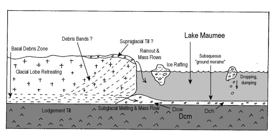
The geomorphic, stratigraphic and sedimentological characteristics of glaciolacustrine sediments in the metropolitan Detroit, Michigan area were studied to determine environments of deposition and make paleogeographic reconstructions. Nine lithofacies were identified and paleoenvironments interpreted based on their morphostratigraphic relationships with relict landforms. The sediments studied are found southeast of the Defiance and Birmingham moraines lying beneath a lowland characterized by a low morainal swell (Detroit moraine) and a series of lacustrine terraces that descend progressively in elevation southeastward. The glaciolacustrine sediments were deposited approximately 14.3-12.4 kA BP during the Port Bruce and Port Huron glacial phases of late Wisconsinan time, and are related to proglacial paleolakes Maumee, Arkona, Whittlesey, Warren, Wayne, Grassmere, Lundy and Rouge. The glaciolacustrine section is typically 2-4 m thick and consists of a basal unit of wavy-bedded clayey diamicton overlain by a surficial deposit of stratified and cross-stratified sand and gravel. The basal unit is comprised of subaqueous debris flow deposits that accumulated as subaqueous moraine in paleolake Maumee along the retreating front of the Huron lobe. The surficial deposits of sand and gravel were formed by traction, resulting from lacustrine wave activity and fluvial processes, in lakebed plain, beach ridge and deltaic depositional settings. Much of the lake-margin sand and gravel was derived from clayey diamicton by lacustrine wave action and winnowing, and that associated with paleolakes of the Port Huron phase is largely reworked Port Bruce sediment. Paleogeographic reconstructions show that the Defiance, Birmingham and Detroit moraines, Defiance and Rochester channels, and the Rochester delta, were deposited penecontemporaneously as paleolake Maumee expanded northward across the map area. A unique type of wavy bedform is characteristic of clayey diamicton deposited by subaqueous mass flow in the study area that is useful for differentiating sediment: 1) deposited by mass flow in subaqueous vs. subaerial settings, and 2) deposited by subaqueous mass flow vs. basal till. These bedforms are a useful tool for identifying subglacial meltwater deposits, and facilitate the mapping and correlation of glacial sediments based on till sheets. The map area provides a continental record of ice sheet dynamics along the southern margin of the Laurentide ice sheet during Heinrich event H-1. The record reveals rapid glacial retreat (~0.8km/yr) contemporaneous with the discharge of a large volume of meltwater. Evidence in the study area for subglacial meltwater is problematic, but indications that periglacial conditions persisted in the map area until ~12.7 kA BP, and extended for 200 km or more south of the ice front suggest that a frozen substrate may have contributed to instability of the LIS. The depositional model presented here provides an excellent example of glacial landsystem F.


2) Howard, J. L., Clawson, C. R., and W. L. Daniels, 2012, A comparison of mineralogical techniques and potassium adsorption isotherm analysis for relative dating and correlation of late Quaternary soil chronosequences: Geoderma, v. 179-180, p. 81-95.
Abstract
Soils developed on late Wisconsinan glacial landforms near Detroit, Michigan were studied to determine their pedological characteristics, and the utility of potassium adsorption isotherm analysis (KAI) for relative dating and correlation. The soils are developed in sediments representing a Holocene floodplain, and late Pleistocene fluvial terraces, fluvial paleochannels, and paleoshorelines (beach ridges) of proglacial lakes, whose chronostratigraphic correlations are already established by geomorphic relationships. The results show that Holocene soils are brown (10YR) calcareous Entisols, whereas late Pleistocene soils have reddish (7.5YR-5YR) cambic and argillic B-horizons (Inceptisols and Alfisols) which show progressive reddening, depth of carbonate leaching, and Fe-oxide accumulation over time. Irregular B/C-horizon boundaries formed as a result of cryoturbation during the late Pleistocene time common. The relative abundance of sand-sized heavy minerals present in the soils is: carbonate > epidote > opaque oxides > tourmaline > garnet > hornblende. Selective sorting appears to be the dominant control over heavy mineral abundances. However, progressive chemical weathering is indicated by a decrease in the abundance of detrital carbonate sand grains in B-horizons, and increasing depth of carbonate leaching, with increasing soil age. Progressive etching and pitting of calcite, apatite and amphibole with increasing soil age, revealed by scanning electron microscopy, is also attributed to chemical weathering over time. The B-horizons of soils studied generally show a systematic linear increase in Kd with increasing age. These trends are positively correlated with increasing clay content and CEC with increasing age, suggesting that ion exchange is the primary mechanism controlling K sorption. The curvilinear nature of some isotherms suggest that specific adsorption of K by vermiculite may also be affecting K sorption to a lesser extent. An excellent correlation between Kd and soil age suggests that KAI is potentially useful as a tool for relative dating and correlation of soil chronosequences. KAI may have an advantage over other techniques commonly used because multiple data points are generated for any given B-horizon sample, which can be plotted to reveal a characteristic shape, and which are amenable to regression analysis. Further studies are needed of chronosequences in other climatic regimes and spanning longer time spans to fully assess the utility of the method.

3) Howard, J. L., Coram, M. R., and Zawiskie, J. M., 2013, Stratigraphy, paleoenvironments and provenance of late Pleistocene glacial sediments in the southeastern Great Lakes region: Implications for ice sheet dynamics. In: Muller, J. and Koch, L. (eds.), Ice sheets: Dynamics, formation and environmental concerns. Nova Pub., New York, p. 1-54.
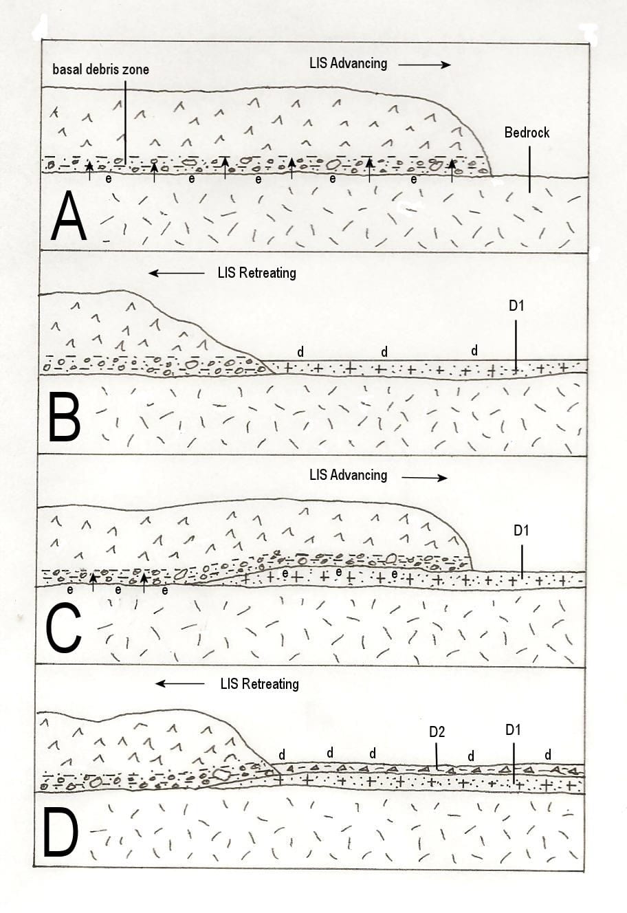
Distinguishing glacial lobes based on provenance analysis of tills is a widespread problem in interlobate terrains. The clast-counting approach and statistical technique tested here successfully differentiated gravelly diamictons in the southeastern Great Lakes region deposited by the Huron and Erie lobes of the Laurentide Ice Sheet (LIS). The approach is potentially widely applicable, and facilitates paleogeographic reconstructions and determinations of ice-flow movements. The method can also be used to reveal stratigraphic anomalies that may serve as an indicator of palimpsest moraines. The Defiance moraine and adjacent glaciolacustrine lowland near Detroit, Michigan are a homoclinal sequence of mainly clastic glacial sediments deposited in subaqueous moraine, lakebed plain, beach ridge, lacustrodeltaic, subglacial and braided-fluvial paleoenvironments. The Defiance moraine is palimpsest and underlain by lower (D1) and upper (D2) depositional sequences, each composed of a subglacial till overlain by deposits of ice-contact affinity. Petrographic analysis shows that sediments deposited by the Huron and Erie lobes can be distinguished based on a provenance in the Superior-Southern and Grenville Provinces of the Canadian Shield, respectively. Clasts of coal derived from the Michigan Basin suggest that D1 represents moraine formed as the LIS moved southeastward during the Nissourian phase (~23-18 14C kA BP), whereas D2 was deposited as the Huron lobe moved southwestward overridding the lower sequence during the Port Bruce phase (~14.8-14.0 14C kA BP), of late Wisconsinan time. Both sequences record very rapid rates of glacial retreat (~0.8 km/yr) and sedimentation (~2m/yr), contemporaneous with Heinrich events H-2 and H-1 in the form of an unnamed pre-Maumee proglacial lake, and paleolake Maumee, respectively. A subglacial origin of meltwater is problematic, but evidence for periglacial conditions suggests that a frozen substrate may have contributed to instability and collapse of the LIS following the last glacial maximum.

4) Howard, J. L., 2015, Glaciolacustrine history of the Huron-Erie lowland in the southeastern Great Lakes region (USA) revisited. Journal of Great Lakes Research, v. 41, p, 965-972.
Abstract
The glaciolacustrine history of the Huron-Erie lowland is reinterpreted using a closed basin model (CBM), based on ground surveys, LiDAR imagery, and digital elevation mapping (DEM). According to the CBM, paleolakes Utica, St. Clair and Rouge were formed about 13,813 cal yr BP in closed depressions as the level of glacial Lake Elkton dropped below that of bounding morainal swells. The CBM explains why no physical connections could be established previously between paleolakes Algonquin and St. Clair, or between paleolakes St. Clair and Rouge. The CBM obviates the need for a spillway at Port Huron during the time of early Lake Algonquin. The Port Huron spillway is reinterpreted as having first formed about 5,728 cal yr BP simply as a consequence of early Holocene glacial rebound, southward tilting of the Lake Huron basin, and rising water level during the Nipissing transgression. LiDAR and DEM maps suggest that spillway development in the Port Huron moraine caused catastrophic flooding during initial formation of the St. Clair River channel. Channeled scablands-like topography in the form of braided scour channels, streamlined erosional residuals, and boulder lag deposits downriver from Detroit suggest that the Detroit River may have formed by outburst flooding as the Detroit moraine was breached by the rising water level of paleolake St. Clair.