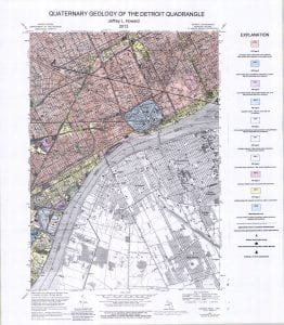
The Urban Geologic Maps, which can be downloaded below, show the geographic distribution of surficial deposits of anthropogenic origin. Anthropogenic sediments, referred to here as “anthrosediments,” are sedimentary deposits formed directly and intentionally by an artificial mechanism of sedimentation. For example, when soil and other Earth materials are excavated, moved around, and backfilled, a deposit of anthrosediment is formed. Urban anthrosediments generally consist of fill, dredged sediments, mine tailings, etc., associated with various types of anthropogenic landforms.
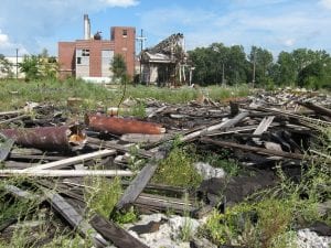
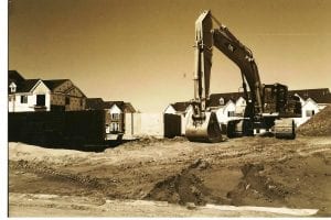
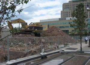
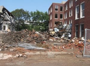
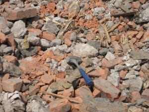
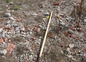
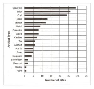
Virtually the entire city of Detroit is underlain by anthrosediment. Currently about 1/3 of the city is vacant land created by building demolition, hence deposits of artificial fill are especially common. Urban anthrosediments in Detroit are typically characterized by artifactual materials in highly variable quantities. Artifacts are gravel-sized objects of human origin, typically coal-related wastes and waste building materials, and sometimes of archaeological interest. Artifacts are often composed of rock-like materials which, in large quantities, can impact repurposing and revitalization of vacant urban land. Different kinds of anthrosediments were distinguished and mapped on the basis of artifact assemblages, which were generally related to former land use, hence the delineations on urban geologic maps appear similar to land use maps.
Click for Geologic Reports: [2013 Detroit Quad report], [2016 Urban Geol report]
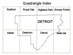
Click for Geologic Quadrangle Maps: [Redford], [Royal Oak], [Highland Park], [Grosse Pointe], [Inkster], [Dearborn], [Detroit], [Belle Isle]
Explanation of Urban Geologic Maps
The Detroit Quad mapping project began with the goal of producing the usual sort of Quaternary geologic map from scattered patches of in situ Pleistocene sediments, and remnants of relict glacial landforms. However, it seemed clear as mapping progressed that most of the natural landforms once present had been completely destroyed by grading and excavation, and artificial landforms constructed subsequently from fill materials. This suggested that a geologic map of Detroit that delineated surficial deposits of anthropogenic origin could be of great societal value. Producing such a map required an experimental approach because techniques for urban mapping were not well established. In this study, a surficial geologic map was produced by classifying the map area into urban geomorphic provinces, and then delineating the map using anthrostratigraphic units.*
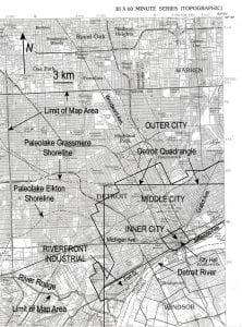
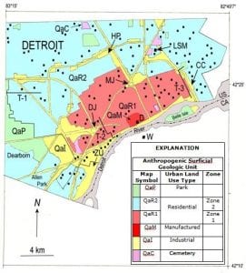
It was evident from the historical patterns of settlement and land use (and existing physical conditions) that the Detroit riverfront could be delineated as an area of predominantly industrial development, and the downtown area as a zone of predominantly manufactured land. Thus, in this study, Detroit was delineated into four urban geomorphic provinces: 1) Riverfront Industrial province, 2) Inner City province, 3) Middle City province, and 4) Outer City province. These cartographic delineations are hypothesized to have geologic significance in terms age and magnitude of human disturbance, thickness and type of fill, water table and groundwater flow characteristics, and type and amount of soil contamination.
*Urban Geologic Mapping
Anthropogenic surficial deposits are formed by human activities which mix, re-deposit or otherwise modify Holocene and older deposits such that their original form is unrecognizable. Because their characteristics are fundamentally different from those of natural origin, special stratigraphic categories are needed for the stratigraphic classification of anthropogenic deposits.
An Anthrostratigraphic Unit (ASU) is defined as a stratiform or irregularly shaped body of anthropogenic origin in the sedimentary record distinguished and delineated on the basis of lithologic characteristics and/or bounding disconformities. An anthropogenic origin is indicated if the deposit: 1) Lies beneath an anthropogenic landform, 2) Contains artifacts, 3) Shows evidence of artificial mixing or other human disturbance, and/or 4) Was imported from offsite and is allochthonous. The basic unit of anthrostratigraphy ASU is the anthrostratum, defined as a mostly stratiform body of artificially mixed earth (rock, sediment, soil, etc.) and artifactual (brick, concrete, etc.) materials. An anthrostratum need only be mappable at a local scale, but anthrostrata of different origins or type may be grouped together as an anthroformation if regionally mappable (Howard, 2014).
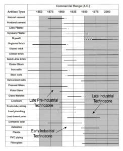
A Technostratigraphic Unit (TSU) is defined as a stratiform body of anthropogenic origin in the sedimentary record defined on the basis of artifacts (objects of anthropogenic origin). TSUs are based on the evolution of technology involved in the creation of artificially altered or manufactured objects. The basic unit of technostratigraphyTSU is the technozone defined on the basis of Commercial Ranges (time from beginning to end of commercial availability of certain artifacts). ASUs and TSUs are applicable to anthropogenic deposits assigned to either the upper Holocene or the Anthropocene.
Urban Surficial Geological Map
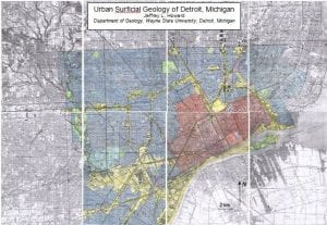
The auger-based geologic map of anthropogenic surficial deposits in Detroit is shown above. Five basic units were delineated, based on Detroit’s historic settlement pattern and land use history. Manufactured Land (QaM) was underlain by a manufactured layer, i.e. an artificial impervious barrier (brick, concrete, asphalt, etc.) comprised of human-manufactured material, as defined in U.S. Soil Taxonomy. This map unit comprised the innermost and oldest part of the city, and was characterized by a mixed landscape of occupied and unoccupied, derelict skyscrapers. The land surface of 18th century Detroit (founded 1701) lies beneath the manufactured ground surface of this map unit. Residential Land in Zone 1 (QaR1) was characterized by strong human disturbance, and was underlain by multicyclic fill (produced by multiple demolition cycles), whereas Zone 2 (QaR2) was underlain by relatively weakly disturbed natural soils, and monocyclic fill. The boundary between Zone 1 and 2 was transitional, but corresponds to the Detroit City limits circa 1910 ± 10 yrs. This boundary was approximated on the ground by a change from an older northwest-trending street pattern (inherited from French ribbon farms), to a younger north-south-trending (Jeffersonian) configuration. Anthropogenic soils in Zones 1 and 2 generally contain abundant 19th century and 20th century artifacts, respectively. Industrial Land (QaI) was located primarily along major railroad lines, and includes airports, marinas and river dredgings. Industrial Land was mainly concentrated along the riverfront during the late 19th century, and involved iron smelting and other processes utilizing coal as a fuel source. Intensive development related to the early car industry caused Industrial Land to expand rapidly along major railroad lines (e.g., Grand Trunk Railroad) during the early 20th century. Cemetery Land (QaC) and Park Land (QaP) were usually small areas up to several hectares in size scattered across the map area. Cemeteries, sometimes dating back to the early 19th century, were generally underlain by human-altered and human-transported materials. Park Land was mainly undisturbed grassland underlain by natural soils (woodland is very scarce). Signs of human disturbance are sometimes common, and some parks are located on former demolition sites.
Explanation of Urban Surficial Geological Map of Detroit, Michigan, USA.
| Anthropogenic Surficial Geologic Unit | Type of Sitea |
Soil Type |
Description | Artifactsb | |||
| Map
Symbol |
Urban Land Use Type | Zone | Abundance | Type | |||
|
QaP |
Park | A |
Native Series |
Rare artifacts and evidence of human disturbance; Native soil parent materials | None | — | |
|
QaR2 |
Residential |
Zone 2 |
A, B, D |
Anthropic and Anthroportic Udorthents |
Monocyclic demolition sites predominate; Artifacts from 20th century common; Complex native and human-transported soil parent materials | Few to very abundant | b, m, t, d, c, w, h, g, n |
|
QaR1 |
Zone 1 |
B, C, D | Polycyclic demolition sites predominate; Artifacts from the 19th century common; Human-transported soil parent material dominant | Moderately to very abundant | b, m, t, d, c, w, h, g, n | ||
| QaM | Manufactured
|
C, D | Land covered and sealed by concrete, asphaltic pavement, etc. | None | — | ||
|
QaI |
Industrial |
C, D | Manufacturing and power-generation industries, airports, marinas, railroads and dredgings; Coal-related and iron smelting wastes common; Human-transported soil parent material dominant | Moderately to very abundant | c, k, d, s, b, m | ||
|
QaC |
Cemetery | A, B |
Anthraltic Udorthents |
Burial plots, crypts and mausoleum; Complex human-altered and human-transported soil parent materials | None | — | |
aSite Types: A, Native undisturbed; B, Undemolished building on weakly disturbed native; C, Undemolished building on fill showing strong human disturbance; D, Demolition site with fill showing strong human disturbance: polycyclic sites showed evidence for multiple demolition events; monocylic or first-cycle sites have undergone one demolition-related backfilling event.
bArtifacts: b, brick; m, mortar; t, concrete; d, coal cinders; c, coal; coked coal; w, wood; h, charcoal; g, glass; n, nails; s, iron smelting slag.
Discussion
Detroit grew rapidly during the 19th century, and was heavily industrialized by the late 1800s, reaching a population of about 600,000 in 1900. It became the center of the automobile industry during the early 1900s, and by 1930, Detroit was the most industrialized area in the United States. Detroit’s population peaked at 1.9 million in 1950, but after World War II, the proliferation of the automobile and the federally funded highway system facilitated the movement of urban residents into the surrounding undeveloped parts of Macomb and Oakland Counties. Many residents even moved to rural or suburban areas, but continued to work in the city. As inhabitants migrated into the surrounding countryside, they left behind abandoned deteriorating buildings and contaminated land. Real estate developers and lending institutions often avoided “brownfield” and other urban properties that could have been polluted because they feared they would be held liable for expensive clean up. Thus, urbanization has continued to rapidly spread farther and farther from the city center, resulting in increased traffic congestion, a loss of prime wetlands and agricultural land, and other environmental problems as developers have opted to acquire “greenfield” locations in suburban and rural areas. Residential and commercial development is particularly intense in the scenic and environmentally sensitive lake and wetland country in the northern parts of the Walled Lake and Pontiac South quadrangles around Walled Lake, Waterford, West Bloomfield, Pontiac, Keego Harbor and Sylvan Lake. However, significant development is also taking place in Auburn Hills, Livonia, Westland, Rochester Hills, Novi, Farmington Hills and Southfield. The Salem quadrangle is largely rural, but urbanization is rapidly encroaching from the east. Recently, downtown Detroit has seen a growing trend toward urban renewal, and there is currently a great deal of public interest in using vacant urban land for urban agriculture, and various types of “green infrastructure.”
PAST PROJECTS
1) Howard, J. L., 2014, Proposal to add anthrostratigraphic and technostratigraphic units to the stratigraphic code for classification of anthropogenic Holocene deposits: The Holocene, v. 24, p. 1856-1861.
Abstract
Anthropogenic surficial deposits are formed from Holocene and older deposits that have been so modified by human activity that their original form is unrecognizable. Because their characteristics are fundamentally different from those of natural origin, the creation of special stratigraphic categories seems justified. Two new material categories are proposed for the stratigraphic classification of anthropogenic deposits. An Anthrostratigraphic Unit (ASU) is defined as a stratiform or irregularly shaped body of anthropogenic origin in the sedimentary record distinguished and delineated on the basis of lithologic characteristics and/or bounding disconformities. An anthropogenic origin is indicated if the deposit: 1) Lies beneath an anthropogenic landform, 2) Contains artifacts, 3) Shows evidence of artificial mixing or other human disturbance, and/or 4) Was imported from offsite and is allochthonous. The basic unit of anthrostratigraphyASU is the anthrostratum, defined as a mostly stratiform body of artificially mixed earth (rock, sediment, soil, etc.) and artifactual (brick, concrete, etc.) materials. An anthrostratum need only be mappable at a local scale, but anthrostrata of different origins or type may be grouped together as an anthroformation if regionally mappable. A Technostratigraphic Unit (TSU) is defined as a stratiform body of anthropogenic origin in the sedimentary record defined on the basis of artifacts (objects of anthropogenic origin). TSUs are based on the evolution of technology involved in the creation of artificially altered or manufactured objects. The basic unit of technostratigraphyTSU is the technozone defined on the basis of Commercial Ranges (time from beginning to end of commercial availability of certain artifacts). ASUs and TSUs are applicable to anthropogenic deposits assigned to either the upper Holocene or the Anthropocene.
Howard, J. L., Orlicki, K. M., and LeTarte, S. M., 2016, Evaluation of geophysical methods for mapping soils in urbanized terrain, Detroit, Michigan USA. Catena, v. 143, p. 145-158.
Abstract
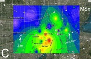
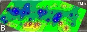
A study was carried out to test the accuracy and utility of field probes as proximal sensing tools for site-specific and regional soil mapping in the heavily urbanized terrain of Detroit, MI, USA. The results suggest that surface scanning in situ with a magnetic susceptibility (MS) field probe is accurate, but limited by tall grass. Better results were obtained after removal of the turf layer. The accuracy of the electrical conductivity (EC) field probe was questionable. Hence, superior results were obtained ex situ using both EC and MS lab sensors. Lab EC and MS were well suited for regional soil mapping, whereas all of the methods provided at least some useful information for site-specific applications. Tall grass, excessive artifact content, and severe compaction were the greatest limitations of proximal sensing. Tall grass interfered with surface scanners (MS; metal detector), whereas excessive artifacts and compaction restricted use of the EC surface probe. Penetrability and pH were useful for discriminating between natural and anthropogenic soils, and moisture content for proximal sensing of soil ^A horizons. MS was especially useful for delineating soils impacted by fly ash. Although it is less rapid and more labour-intensive than field methods, the lab-based approach still provides a minimally invasive alternative to augering. Lab-based geophysical surveying can be carried out first, and the results used as a guide for an auger-based soil survey. An anthropogenic map index (AMI) is introduced which combines pH, penetrability, EC and MS into a single overall measure of soil quality. AMI-based maps are postulated to be a useful as a geographic representation of soil health. These results support our hypothesis that proximal sensing methods can facilitate soil mapping in urbanized terrain based on the degree of human disturbance, and differences in artifact assemblages related to land use history.
 Urban Geology of Detroit